A guided walk through the historical centre of Withington
Introduction
Withington was a small rural village until the mid-1800s. It was mainly agricultural, with most of the population employed as farmers and farm labourers. Withington did, however, have a mains supply of both gas and water from an early period. Gas was laid on from Manchester in 1852, and mains water, as far as the White Lion, was available from 1854.
The 1801 census showed the population of Withington to be 743 in 133 dwellings. In the 1851 census, this had doubled to 1,492 in 265 dwellings, and in 1891 a further tenfold increase to 14,213 in 2,541 dwellings2.
Travelling along what is now Wilmslow Road in the mid-19th century, one would see some cottages and farmhouses, together with a few, more substantial houses, as well as several public houses, the newly-built parish church and parsonage, and, on Burton Road, a smithy and wheelwright's shop. Apart from this, on both sides of the road, the land was almost entirely agricultural.
Withington and West Didsbury Railway Station opened in 1880 on Lapwing Lane/Palatine Road8:
The station opened as "Withington station" when the Midland Railway opened its new Manchester South District line out of Manchester Central Station. It was renamed "Withington & Albert Park" in 1884, and then "Withington & West Didsbury" in 1895. The Manchester South District line and the station closed in July 1961. By the 2000s, the original cobbled station approach road and wall were still visible off Lapwing Lane, and the remains of the station platforms could still be seen at the bottom of the overgrown embankment. Manchester Metrolink is now using this section of the route, with West Didsbury station opening nearby in 2013.
The building of the railway station in 1880 heralded a new era and much of old Withington disappeared as urbanisation continued. The once-rural village developed rapidly into a large, bustling suburb of Manchester. However, even as late as 1886, cows and sheep were still driven through the centre, and pigs were kept on Burton Road2. The rural origins of Withington are recalled in the continuing tradition of calling the district centre "The Village".
From 1876, Withington was run by a Local Board with an extensive area of governance. Between 1894-1904, Withington became an Urban District Council. The former Withington Town Hall (1881) still remains as a fairly ornate building on Lapwing Lane, near the junction with Palatine Road. In 1904, Withington was incorporated into the City of Manchester.
At a later period, in 1915, Withington was described4 as "Wealthy, a kind of upper-class Olympia, with a rather pronounced air of ‘culture’ and the higher life" and Moss-side as "middle class" and“clerky” with "ambitions inclining to the semi-detached"!
The Walking Tour
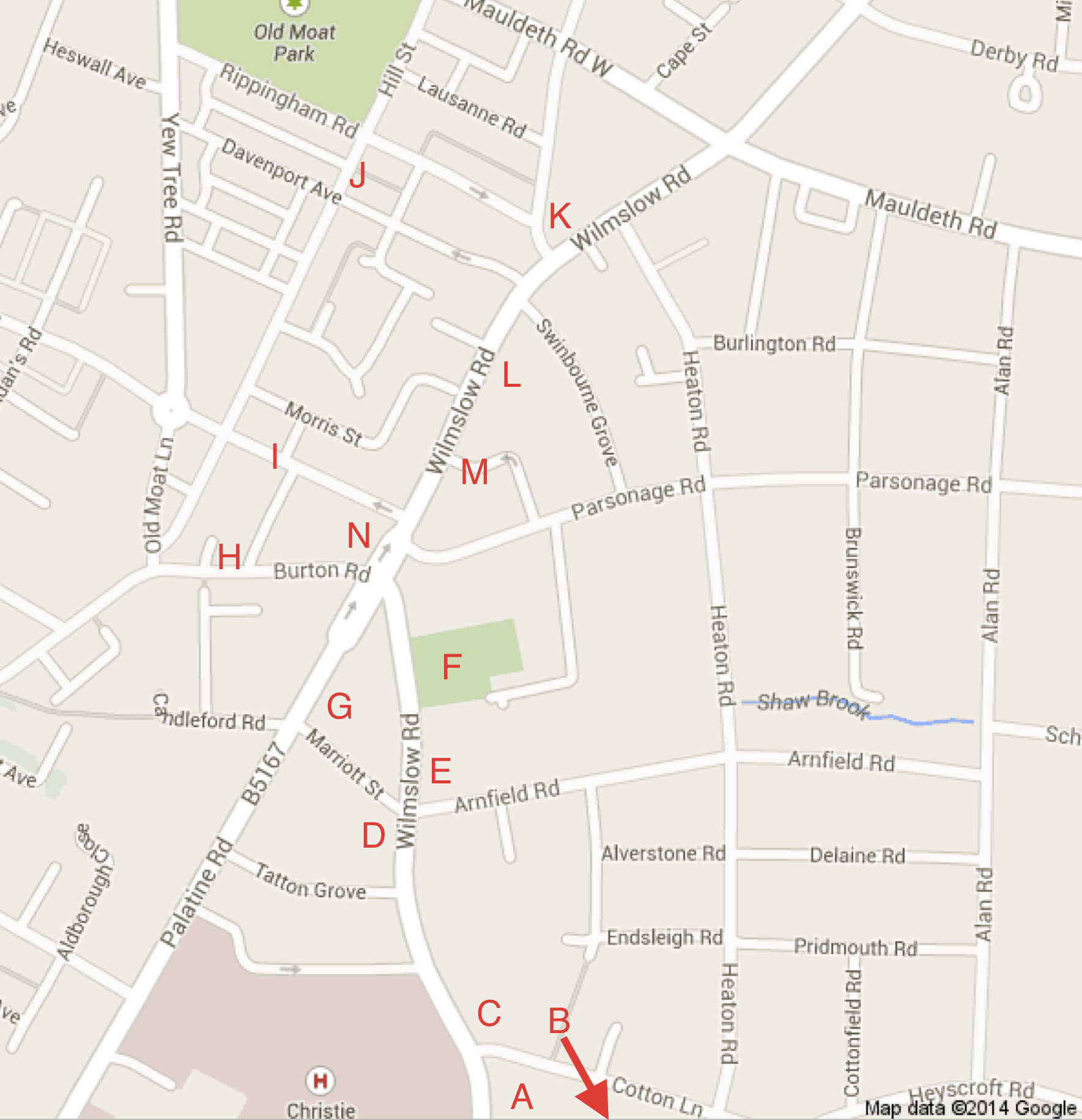
- We begin the walking tour of Withington, starting at the corner of Cotton Lane and Wilmslow Road (location A on the map).
A. Withington Green
Withington Green is a roughly triangular piece of land at the junction of Wilmslow Road and Cotton Lane. Johnson's Plan of the Parish of Manchester6 (1820) records the settlement over a wider area as "Withington Green", suggesting that the Green itself is considerably older. Withington Green is also marked, as public land, on the Withington Tithe Map of 1845-48. The Green was known locally as "the diamond". In the Victorian period and later, ornamental trees and flower-beds were introduced with a variety of designs over the years. With the building of the adjacent Manchester Cancer Research Centre (now the Oglesby Cancer Research Building), completed in 2015, the Green has undergone further redesign.
B. Maggie’s Manchester
Just south of Withington Green, on Kinnaird Road, is Maggie’s Manchester22. This is well worth a diversion from the walking route. There are Maggie’s Centres across the UK providing support for people with cancer, and for their families and friends. The Centre in Withington, The Robert Parfett Building, was the 18th to be built, and was, at the time, the biggest in the country. The building has an innovative design by Stockport-born architect, Lord Norman Foster.21 The gardens were designed by Dan Pearson, an RHS Chelsea Flower Show award winner. The facility was opened in 2016 by the Duchess of Cornwall. The building and gardens are a splendid addition to Withington.
- Return to Cotton Lane at Withington Green.
C. Cotton Lane
Cotton Lane runs east from the Green. It is an ancient thoroughfare, recorded on Johnson's 1820 Plan of the Parish of Manchester6 but is likely to be much older.
The area to the east of the Green, called Cotton Tree Field, Cotton Field or Cotton Doles, is a remnant of one of the ancient open fields of Withington6. The origin of these names is not clear. Whittaker2 suggests the name probably comes from "co-town strips making up the fields at the far end (of Cotton Lane)" - part of the old open field system. This may well be correct, but "cotton tree" suggests poplar trees, which are sometimes known as “cotton trees” or “cottonwoods" from the downy seeds. The Cotton Tree public house on Cotton Lane, whose name recalls the old Cotton Tree Field, was demolished in 2011 and replaced by flats.
The Christie
The first Christie Hospital building was opened in 1932 by Lord Derby13. This brought together two previously separate institutions: the Christie Hospital, named after Sir Richard Copeley Christie, once chancellor of Manchester University; and the Holt Radium Institute, named after Sir Edward Holt, a former Lord Mayor of Manchester. The hospital is now (2020) one of the largest cancer treatment, research and education centres in Europe.
The Grange and Tatton View
The Grange (at the north corner of the junction of Wilmslow Road and Cotton Lane) now (2020) houses a Muslim Preparatory School. It was previously a 'rest home', and before that the property of the Amalgamated Society of Woodworkers - hence the ASW initials on the gatepost. The present building is depicted on the 1892 OS map. The previous building on this site was a farm called the 'Old Mill Dam Farm', belonging to the Lord of the Manor, the Egertons of Tatton.
- Cross Wilmslow Road to Tatton View, off Tatton Grove.
The date of the houses in Tatton View is 1879. All the house numbers are even. In the gardens of the present houses, there were planned to be similar houses, taking the odd numbers. However, when the ground on this side was surveyed, it was discovered that a brook ran underneath (Shaw Brook or a tributary of it10), and so the land was unsuitable for building. Tatton View forms the southernmost part of Withington Conservation area and the houses here are some of the best examples of Victorian terraced houses of this size in the area.
- Walk to the Red Lion public house.
D. The Red Lion
The Red Lion is Withington's oldest building and is Grade II Listed. The present building is believed to be at least 200 years old and the site possibly older. It was the location of a local court, the Withington Court Leet, until 1841, and the meeting place for the Trustees of the Turnpike Trust for (what is now) Wilmslow Road2.
The Red Lion used to be the focus of the so-called “rush cart procession”, as recounted in Kenneth Whittaker's A History of Withington2: "This took place on St. Oswald's day, the fifth of August. The rushes, which Withington provided to strew on the floor of the Parish Church at Didsbury, were piled onto a large waggon and escorted with mime and dancing. The procession was held for over six hundred years, surviving well into the nineteenth century. In later years, the rush cart was made up at Mee's Farm, at the rear of the 'White Lion'. Sometimes the date 1603 was designed in marigolds on the cart. Fletcher Moss suggested that this date indicated when a cart was first used to carry the rushes. Before it, men or pack horses would have been used."
It is recounted that, around 1872, Wilmslow Road was flooded outside the Red Lion and apparently the inside of the pub became flooded too. Some ducks made their way inside from a nearby pond and swam around for a while quite contentedly.2
- See opposite on Arnfield Road.
In Arnfield Road, on the south side, the first house (No. 4) is a replacement. The original building (houses nos. 2 and 4) was hit by a bomb in 1940, badly damaged, and then demolished.3
- Walk across Wilmslow Road to the corner of Arnfield Road.
E. Old Police Station, Fire Station and Forge
The present fire station (now the Withington Community Fire Station, 2020) is the first in the area. Before being built, the nearest fire station was in the centre of Manchester. The current building has flats for accommodating fire-fighters. It once housed a police station as well. The combined building was constructed in 1931. There was, however, a smaller police station here before this building. The original had no cells and any detainees had to be taken to Didsbury. The police station moved from here to Copson Street/Hill Street and operated as a 9am-5pm station from 1981, but is now closed.
Look for the old milestone nearby. In 2013, it was Listed (Grade II) as a monument of special historical interest, thanks to the considerable efforts of Anna and Alan Highfield, who prepared the case for submission to English Heritage. There were once milestones and mileposts at 1/3-mile intervals along both Palatine Road and Wilmslow Road in Withington. This is the only example remaining. English Heritage suggest that the milestones and mileposts were installed by the Turnpike Trust (see below).
The next building northwards is the forge. This was owned by the Priday family, and founded by William J. Priday - see the initials "WJP" on the left-hand side of the entrance, and the foundation date of 1881 on the right-hand side. William Priday is buried in St. Paul's churchyard where you can still see his gravestone. The Priday family ran a forge on Burton Road long before 1881. Jack Priday, who lived in Gatley until his death in October 1991 at the age of 88, was awarded the BEM in the New Year's Honours in 1988. Until a few months before his death, as the official farrier to the Manchester City police force, he used to attend regularly to the horses at Hough End Farm in Old Moat Lane. Upstairs in the forge there used to be a loft which housed a collection displaying the coach-builders’ craft. The forge yard once housed the village pump and the schoolmaster's house was nearby3. Behind the forge frontage, the building has been replaced by modern flats.
Shaw Brook10 runs past the forge, and can be seen in the courtyard at the rear. The brook rises in Shawfield, Heaton Moor, near to Shawfield School, and flows through Burnage to Withington. It is visible from Alan Road (near the corner with School Grove) all the way to St. Paul’s Primary School, and then through to the forge, where it enters a culvert and passes under Wilmslow Road (maps often show only part of this route). It then runs underground to the north and west of the Red Lion (from where it was sometimes called the “Red Lion Brook”) under the gardens of Tatton View, and then turns westward to reappear at Hough End as Chorlton Brook, and eventually runs into the Mersey.
Wilmslow Road
Across the road is the Turnpike public house (closed in 2018, and now for sale). The name reminds us of the one-time status of Wilmslow Road, which was previously called Turnpike Lane and earlier still High Street. This was one of the ancient routes south from Manchester (see old maps of the area6). Indeed, there is a suggestion that it may have served as a medieval “saltway”2. Between 1753 and 1881, the road was a turnpike road run by the Manchester and Wilmslow Turnpike Trust, created by an Act of Parliament. The Trust upgraded the road and built Northenden Bridge over the Mersey in 1867. These improvements were funded by tolls charged on road users. Before the bridges were built over the Mersey, the road forded the Mersey at Ford Lane in Didsbury, where it crossed by a diagonal route. Toll bars prevented people getting free access to the turnpike road and, at various times, these were at Mauldeth Road, Burton Road, Cotton Lane and Fog Lane, but no remains of these are visible2.
- Walk northwards along Wilmslow Road to St. Paul's church.
F. St. Paul's Church
Before the mid-19th century, Withington did not have a parish church. It was part of the large Parish of Manchester. There was however a chapel in Didsbury (now St. James' Church) which served as the local place of worship. St. Paul's parish church was consecrated on 21st October 1841. There were churches in Withington prior to this, for example, the first Wesleyan Methodist chapel in Withington was built in 1832. Originally, St. Paul's church served the people of Withington, Fallowfield, Ladybarn and Burnage. It cost £2,790 4s 4½d to build (notice the ha'penny ½d, half of an old penny!) and had seating for 649 people.
In 1847, the church's first organ was played by Felix Mendelssohn, the composer, who was staying nearby. According to a churchwarden’s account of 1896, Mendelssohn “played a service and gave a recital upon the organ and it was pronounced by him to be an excellent instrument”.2,11
Before its enlargement to its present size, the church had no lady-chapel or choir vestry. These were added in the late 1850s, as was the clock in the tower. The church was re-opened in 1863 after the construction work. In 1894, the old lych-gate was replaced with the current one. In the early days of the church, church-goers paid annually for pews: side pews cost 5 shillings p.a., chancel seats 15s p.a. and front seats 17s 6d p.a.
An incident took place here one Sunday in 1855. At this time, Sundays were meant to be strictly observed. This particular Sunday, the churchwardens, sidesmen and duty constable, after the first lesson had been read, left the church to parade around the parish to check that there was no disorderly conduct during the time of the service. They picked up two men and brought them back to the church just before the sermon. Their crime? Gathering nettles from the fields into bags to make nettle wine! The bags of nettles were confiscated, but when the service was over, they were returned to the men and they were sent on their way with an admonishment from the vicar that they should, in future, treat the Sabbath as a day of rest2.
In December 1940, a mine fell by parachute and became caught in a tree in the churchyard to the north of the church. Everybody in nearby buildings was evacuated, but it failed to explode and was later defused.
St. Paul's School
Adjacent to the church is a building which was once St. Paul's School, but has been converted into flats. On the wall is a plaque recording the dates: Erected 1844, enlarged 1865, 1878, and rebuilt 1896. The headmaster between 1896 and 1926 was Herbert Thomas Scholes. He would send misbehaving children to the forge, with a note to Mr. Priday to allow the child to pump the bellows for him during playtime!
Behind the school was the playground and, at one time, there was a corrugated-iron hut in a corner in which the 1st Withington Girl Guides used to meet. This company was founded in November 1918 by Elsa Carroll, when she was a pupil in her last year at Manchester High School for Girls.
- Go down Marriott Street (the terraced houses here are c1880) to Palatine Road.
Palatine Road
Palatine Road was originally called Northenden New Road, and was built as a turnpike road in 1863 (a late development for turnpike roads, which were abolished in 1881). In the late 1880s, the Post Office requested that the section as far as Northenden village be renamed Palatine Road. The name originates from the fact that the road ran between what were two “Counties Palatine”: Lancashire and Cheshire. These counties, in the past, had a degree of autonomy from the Crown and Government.
This road provided the tram service to Manchester. Electric trams replaced horse-drawn trams in 1902 on the route. For the horse-drawn trams, the fares from Withington were “6d [old pence] inside, and 4d outside".2 Alternative means of transport at the time were horse-buses and horse-drawn cabs, and trains from Withington Station (see above) and from Fallowfield Station which opened in 1891. Trams were replaced by buses on the route in 1938.
G. St. Cuthbert's Catholic Church
The Roman Catholic church of St. Cuthbert's on Palatine Road was originally dedicated to "The Holy Ghost and St. Cuthbert". The church was established in 1874, and the nave opened in 1881. The building was extended in 1902. The architects for part of the extension were W. Telford Gunson and Sons (see the foundation stone).
Before this church opened, the Catholic community in Withington worshipped in a large room loaned to them by one of the householders living in Marriott Street. Earlier still, Mass was held in another private house called "Mount Street Joseph", which was on the site of the current Withington Library (on the corner of Wilmslow Road and Wellington Road).
Provost/Canon Rowntree was appointed as rector of St. Cuthbert's in 1896 and served the Catholic community until his death in 1952. He was followed by Canon O'Leary 1952-1974.17
St. Cuthbert's School (1891) was adjacent to the presbytery until about 1908, when it moved to its present position on Cotton Lane. The former school building is still there and serves as a church hall.
Candleford Road and Passage
Looking across Palatine Road, you will see Candleford Road and Passage, leading to Burton Road. The passage was known locally as Boggart's Entry. 'Boggart' is a Northern dialect word, related to 'bogeyman', meaning a ghost or spectre ("especially a local goblin or sprite supposed to haunt a particular gloomy spot, or scene of violence" - Oxford English Dictionary). The passage is a former farm bridle path, and was edged on one side with 5ft high flags. These have now disappeared.
- Walk towards the junction of Palatine Road and Wilmslow Road and turn into Burton Road.
H. Burton Road
Around the 1880s, Burton Road was known as White Lion Lane, later Burton Lane. It was also known as Back Withington Lane and Burton Farm Lane. Priday's old forge or smithy, founded 1800, was at No. 3, Burton Road, directly opposite Withington Public Hall3.
A group of interesting buildings stands on Burton Road between the junction with Wilmslow Road and the Baths. These include, on the north side of Burton Road adjacent to the White Lion, an unusual small building which is Withington Public Hall and Institute. It has the date of 1861 in the brickwork, and was a gift of Lord Egerton of Tatton to Withington. The Hall has functioned as a members club since 19062, and, in the 1990s, it had a membership of approx. 400. It housed (1861-1911) an early lending library for Withington (see below) and, in the main room, there used to be a large fire in the winter for members and visitors.2 The building no longer functions as a club, and its future is yet to be determined (2020).
The Orion Hotel is a public house on Burton Road. On December 18th 1867, John Hamnet Norbury, a stonemason and builder, bought the plot on which the Orion stands, for an apportioned chief rent of £16.18s.6d and built two houses on it, one of which had a stonemason's yard adjoining. The second house became a public house called the Orion, and John Norbury became the first landlord and licencee. On 22nd June 1875, John Norbury sold the plot with the two houses to Broadbents, the brewers. The second house became a storehouse for beer barrels. The Orion is named after a 19th century HMS Orion, on which John Norbury served14. The ship depicted on the sign is a more recent warship.
What used to be a Primitive Methodist Chapel stands on the corner of Old Moat Lane and Burton Road. It is now (2020) an Adult Learning Centre. Primitive Methodism was a movement in Methodism from about 1807 until the union with Wesleyan Methodism and United Methodism in 1932, to form the Methodist Church of Great Britain. A previous place of worship for the Primitive Methodists from 1880 to 1890 stood on Old Moat Lane - there are reports that this took place in a room above what is now the shop on the corner of Hill Street and Old Moat Lane. The church's foundation stone (much defaced) is dated 1891. Worship continued here until September 1954. Since then, Methodist worship has taken place at the Methodist Church in the village centre. The shop on the corner of Old Moat Lane and Hill Street was at one time a plumber's shop owned by Peter Donnet2, and then it became Walsh’s DIY store (closed 2019).
Withington Baths (now Withington Leisure Centre, 2014) has a datestone of 1911, and was built immediately to the north of a cricket ground on Burton Road. The building was designed by Henry Price (1867-1944), a City Council architect, who also designed Withington Public Library. The style of the Baths combines elements of Art Nouveau and the Arts and Crafts movement. The Baths had separate entrances for men and women. Despite this, it was the first Baths in Manchester to allow mixed bathing (in 1914). In the Second World War, on New Year's Eve 1940, an air-raid shelter in front of the baths took a direct hit. Seven ARP wardens were killed.
The centenary of the Baths in 2011 was celebrated with a community party.19 In a recent development, on June 22nd 2015 the Baths re-opened as a community-run leisure centre.
Facing the Baths is the site of the Waterloo Inn/Hotel, now Brigadier Close. The name of this public house is taken from the annual dog coursing event, the "Waterloo Cup". William Foulkes, who lived in a house that was previously on this site, picked up a stray dog, which he called "Brigadier". The dog was trained by a Mr. Gordon and, in 1866, it won the Waterloo Cup. When the dog died, it was buried in the grounds. The tombstone read: "In Memory of a Faithful Friend, Brigadier, Winner of the Waterloo Cup, 1866. Died September 18th, 1877, aged 14 yrs 3 months”.2 The pub has been replaced by a housing development, but the name of the dog has been preserved in Brigadier Close. A plaque commemorating Brigadier's achievement disappeared for a while but was reinstated in early 2013.
- Cross over Burton Road and cut through Patten Street, by the Orion Hotel, into Copson Street.
I. Copson Street and the Withington Trough
Copson Street was formerly called Cooper Street, and used to house well-known family shops, including Hope's butchers and Gough’s greengrocers.
Withington trough is located towards the west end of Copson Street. It started its life outside what is now Withington Public Library in 1876. In 1927, it was moved to the junction of Palatine Road and Wilmslow Road, near the White Lion public house. There are personal recollections of the trough apparently being moved on several more occasions:
"At the White Lion stood the Horse Trough where the horses which drew the milk floats, the bread vans and the coal carts could stop for a refreshing drink." K. Glyn Jones in Bygone Withington (1977) recalling a period around 1927.18
"At the junction of Wilmslow Road and Palatine Road there was a large horse-trough, and a drinking fountain with a drinking cup fastened by a chain. This was later moved to a new location in front of Withington Library, but disappeared from there many years ago.” Jack Jordan in Bygone Withington (1977).18
One of the Civic Society correspondents, Steve Partington, recalls: "the horse trough was at the bottom of Cotton Lane alongside Withington Green from my earliest memory in 1953, until we left in 1968. My Dad used to take a drink from the enamel cup that was attached to a chain at one end, so it was plumbed in with fresh water, at that location.” (Personal note, 2010)
The trough disappeared for some years. The story of its rediscovery is of interest: a free paper called the "Withington Reporter", published by a volunteer group, advertised for information on where the trough may be. Many sightings were received! It was Mrs. Tidmas of 2, Old Moat Lane, who reported finding it, quite neglected, in a field at Chamber Hall Farm, Heald Green. The farmer asked for a tin bath as replacement and this was provided! The trough was then returned to Withington in 1985, thanks to the efforts of Withington Civic Society. The Society arranged for its removal in sections to the current site, secured planning permission for its installation, and restored the area around the trough.
The inscription on the water trough
"... that ye may drink, both ye and
your cattle and your beasts" [2 Kings, 3:17]
is appropriately chosen: the trough provided water for people with a cup at the front, for horses, and for dogs at the side.
Old Moat
Old Moat Lane was originally called Old Hall Lane, when it had a different alignment (see old maps of the area6). It led to Withington Old Hall, near the old moated house which gave the area its name of Old Moat. See the Civic Society website16 for details of the history of this area.
- Walk up Hill Street.
Hill Street
In the early part of the 20th century, Withington was perceived as exemplifying a wealth divide, two populations separated by Wilmslow Road, with the poorer area in the west and the richer area in the larger houses to the east in the Parsonage Road area. The divide is no longer so evident as there have been new developments on both sides of the road and a good deal of renovation.
- Look down one of the entries at Hazelbank Road.
Notice the central drain and the back view of the houses which are, for the most part, unchanged since they were built in the late 1880s.
- Walk down Davenport Avenue.
J. Davenport Avenue and Old Moat Park
Davenport Avenue was named after a Mr. Davenport who owned a house on part of the land on which the avenue stands. In 1817, he allowed the Wesleyan Methodists to use a harness room attached to his house, which they did up to his death.
In 1908, there was a land dispute between the Egertons of Tatton Hall, who once owned much of the land in the area, and a local grocer, Mr. McMinn. A strange consequence of this is that a wall was erected dividing Davenport Avenue at Moorfield St/Ave. This was referred to as "Waller's wall”: Frank Waller being a local electrician. Old photographs of the wall show it as a substantial barrier across the road3.
The streets in this area are essentially unchanged since they were built between 1862 and18926.
- Walk along Rippingham Road eastward to Wellington Road and the Public Library.
Rippingham Road is named after Mr Rippingham, the builder of the houses in this road, and possibly nearby roads. There used to be a pickle factory, selling products under the name "Olde Farm” on Rippingham Road, which was founded in 1919. The owner retired in 1989. Notice the carved street sign dated 1895, and the signs for Claremont Terrace (1890) and Oak Bank (1891).
What is now Old Moat Park (5.6 acres) between Rippingham Road and Hill Street, with a children’s play area, lawns and artworks, was a recreation ground, with a bowling green and bandstand recorded as far back as 19166, when it was bordered by agricultural land on two sides.
K. Wellington Road and Withington Library
At the junction of Wellington Road and Wilmslow Road once stood the village stocks!2
Kenneth Whittaker describes the history of Wellington Road2: "The road was previously called Raspberry Lane but John Baird, writing in the 1896 Bazaar Handbook, suggested that this was a corruption of Rasperé Lane. The name Rasperé had been taken from a Frenchman who resided there. Whatever the correct explanation, the Ordnance Survey sheet of 1848 gives an added twist by naming it Rassbeaur's Lane."
Two streams cross Wellington Road10. At the former railway bridge, Fallowfield Brook is visible to the west of the road. Further south, Leigh Brook is culverted under Wellington Road at Victoria Road. This is marked as Leigh Brook on the 1862 OS map6, and Ley Brook on the Tithe Map (1845-49). On both maps, the crossing is named as "Rassbeaur's Bridge".
Withington Library: Before the purpose-built library, there was a lending library as far back as 1861 in Withington Public Hall, which stands on Burton Road (see Page 14). This had 1,200 books5 in 1895 - a considerable number at that time. Fletcher Moss, of the Old Parsonage, Didsbury, campaigned for a library in Withington during his time as alderman. Nothing resulted. The following quote from Fletcher Moss's Fifty Years Public Work in Didsbury5 indicates the state-of-mind of some people at the time:
"In 1895 and several succeeding years, I moved a resolution for the adoption of the Public Libraries Act and was always sat upon by the conservative majority. Mr Joe Lunn (Conservative builder) of Withington told us that there was a library in Withington in an upper room somewhere behind the White Lion and all the folk that ever went into it were a few women a week. What was the good of having another library?"
On 13th October 1911, a library service was set up by the City Council in a house on the site of the present building. This had a stock of 1,861 books, as well as a newsroom. It soon became clear that a more substantial service in a purpose-built building was required20.
The present building was designed by Henry Price (1867-1944), a council architect who also designed, at an earlier date, Withington Baths. The library is one of the many "Carnegie libraries" in the UK, partly financed by a fund set up by the Scottish-American industrialist, Andrew Carnegie (the donation was £5,000, from a total cost of £15,500). The building was opened in 1927 by the Earl of Elgin and Kincardine (Treasurer of the Carnegie UK Trust and President of the Library Association). He became the first borrower of a book, a copy of James Tait's Medieval Manchester and the Beginnings of Lancashire (1904).
A one-time librarian, Miss Starkey, used to encourage Robert Donat, before he became the famous actor and Oscar-winning film-star, to use the library to improve his skills in the profession by practising reading.20
Withington library was one of the first in Manchester to have a young people's reading room. Children had to be at least 9 years old and in Standard 3 to join. There was a librarian for young people available at certain times. Those qualified to join would get a ticket saying when they could use the library to read books, but they were not allowed to borrow them.20
Across Wilmslow Road from the library, there used to be Withington's first Post Office and sorting office until they moved to separate purpose-built premises. The Post Office is now in Egerton Crescent, and the sorting office further north on Wilmslow Road.
Between 1907 and 1919, Ernest Rutherford, later Lord Rutherford, the pioneering atomic physicist, working at Manchester University, used to live on Wilmslow Road, north of the Mauldeth Road junction on the east side, in a substantial house now called Rutherford Lodge. There is a blue plaque on the building recording his residence here.
- Cross the road to the former bank building.
The “Old Bank”: a former branch of NatWest Bank
A branch of the Manchester and County Bank opened on Wilmslow Road in the Oak Bank Buildings on 1st August 1877. This building, which has a datestone of 1876, has ornate, rather Italianate, brickwork and stands on the south side of the junction of Davenport Avenue and Wilmslow Road on a site that was formerly gardens.
The bank moved across the road to the present building (1890) designed by architects Mills and Murgatroyd. It was purpose-built and has an attached house on Swinbourne Grove, in which the manager was required to live. This house became offices sometime after WWII. Although purpose-built, the southern half of the ground floor frontage was originally a shop. From 1903/4, G.F. Leather (Draper and Outfitter), held the tenancy of the shop, trading here until 1912 when the shop moved across the road to 416, Wilmslow Road. This shop traded at various premises from 1898 until 1978, making what is likely to be a record of 80 years continuous trading in Withington. No sign of the shop remains in the present building.
The original banking company has been taken over several times: it became a branch of the District Bank in 1935, The National Provincial in 1963, and the National Westminster 1970. However, this branch never traded as the National Provincial, continuing as the District Bank until it became National Westminster in 1969/70. The building is Grade II Listed. It was vacated in 2016 and iscurrently (2020) unoccupied, though hosting “pop-up” events, and with plans to become a community facility.
Opposite the bank, there was a bakery whose first owner, at the turn of the century, was Mr. Schule from Germany. In 1935, this shop was bought by a Mr. Duwe, also from Germany. It closed in 1969.
- Walk southwards along Wilmslow Road through the Village looking out for the following buildings
L. Withington Methodist Church
Withington Methodist Church in the village centre was built in 1865. Extensive redevelopment work was undertaken in 1992.
The origins of the church are recounted on the church website12: "Withington Methodist Church owes its origin to the vision of two twelve-year-old girls, Hannah Hesketh and Hannah Langford, who, in the 1790s, heard the gospel in neighbouring Burnage and asked that a bible class be run for them in Withington. From this class, held originally in farmhouse kitchens, a worshipping community developed who, in 1832, erected a small chapel in old Moat and subsequently built the present building in 1865."
The first Methodist services in Withington were held in a room hired from a handloom weaver in the village, called Cash. This room was in a previous building on the south corner of Wilmslow Road and Egerton Crescent. Services were held as early as 1801. A Wesleyan Methodist church was built on Old Hall Lane, and was in use from 1832 to 1864, when the congregation moved to its present site. There was also a Primitive Methodist chapel on Burton Road (see Page 15).
Victoria Hotel
In 1862, the land on the site of the present Victoria Hotel was sold. In 1905, Hydes brewery bought the site from Mr. W. M. Kay. The pub, at the time, had a basement below, a flat above, a small stable behind and, in the yard, a small cottage. In 1906/7, Hydes demolished the cottage and stable, extended the public house at the rear and built the single storey side section on Queen Street. The interior was renovated in 1984, but the exterior has remained unaltered.
Albert Hotel
The Albert Hotel and the shop next door are the oldest surviving buildings in the centre of Withington. On 26th October 1793, John Rigby, described as a “yeoman of Withington”, sold to John Bowker three acres of land. In 1824, Edward Langford, a joiner, acquired a dwelling house, gardens and premises probably on this land. Between 1824 and 1829, he built three cottages, which, in 1852, he sold to Thomas Holt, a cashier. During the next ten years, Thomas Holt converted the three cottages into two tenements to form a beer house, a shop and a dwelling house. The first mention of the public house by the present name (as the “Albert Inn”) was in 1897.
Queen Street West
This is a short street running off Wilmslow Road and retains several old buildings. Towards the end on the right is a building that was recorded as a smithy on the 1916 OS map6, and is now a car repair shop. On the left is a former stable building with hayloft and hoist. Both buildings are adorned with horseshoes! Stables and smithies were a common sight throughout the country when horses were the principal means of transport. Most have now been lost.
The former Barclays Bank building
The former Barclay's Bank building, on the east side of Wilmslow Road, is one of several prestigious bank buildings in the village. The Bank acquired the freehold interest on this property on 26th May, 1903. The branch opened on 5th September, 1904, and cost £5,100. It closed in the early 21stcentury, and has since been used as a bar and restaurant.
M. Egerton Crescent
Egerton Crescent takes its name from the Egerton family of Tatton Hall, who were formerly Lords of the Manor and major landowners in the area. On the left-hand side of the entrance to the crescent, in the 1930s, there used to be a chemist shop, operating from a cottage on the site. For a prescription, one walked down the garden path and knocked at the door!
On the south side of the entrance to Egerton Crescent, the stone-faced building was once a branch of the Royal Bank of Scotland, recently closed (2018). It was originally a branch of Williams Deacon's Bank. In 1801, there was a private house on this site belonging to Mr. Cash, a handloom weaver. Methodists held services here and founded the first Sunday school in Withington in 1829, and also a day school. Across the road, on the corner of Copson Street, there was a high-class grocers shop, owned by Morley Brooks, which later became a contact lens/spectacle shop.
Scala Cinema
On the corner of Copson Street and Wilmslow Road, there used to be a cinema, one of two in Withington (the other was “The Palatine Picture House” on Palatine Road, which closed in 1960). The Scala Electric Palace, which, in its last years, was called Cine City, opened in 1912 and became one of the longest surviving cinemas in the country7. Before sound pictures, the Scala had a woman pianist and many people came to hear her as well as watch the silent movies. The steps outside the cinema were often used to announce election results. The building was hit by a small bomb in October 1940. The cinema closed in July 2001, and, despite protests, was demolished in 20087. A mixed-use building, with a frontage recalling the former cinema, has been erected on the site (opened 2019).
In the mid-1930s, there were 109 cinemas in Manchester and people often visited cinemas 3 or 4 times per week. By 1965, the number of cinemas in Manchester had dropped to 40.7
Across the road from the the Scala building, there is a big house on the south corner of Parsonage Road. The house previously on this site was the original St. Paul's Rectory/Parsonage, hence the name of the road.
N. The White Lion Hotel
The large building on the north corner of Wilmslow Road and Burton Road is what was once the White Lion Hotel. There is a white lion on the tower. It was formerly called the Withington Ale House, and is now a Grade II Listed building. There was a previous building on this site, built sometime in the 18th century, also called the White Lion, which was probably altered or rebuilt in 1840. The present building has an inset on the north wall chimney with a date of 1880. The architect unfortunately died before the building was completed. At one time, it was the custom for the White Lion to present prizes on May Day to the best local horse teams. The most untidy horse also won an award - a curry comb, an instrument for grooming horses!2
Renovations to incorporate a supermarket took place in 2010-11. Much of the interior has been preserved, including some fine stained glass and a well in the basement. At the rear of the building is the former stable yard with a coach-house. The pillars in front of the building are historical features and Grade II Listed.
Further reading
Withington Civic Society website contains a collection of articles covering many aspects of the history of the area. You will also find a list of local history resources: www.withingtoncivicsociety.org.uk.
Acknowledgements
This history walk originated as typewritten notes by the late Louise Kane, an MCC Blue Badge guide and a member of the Civic Society. Louise led Withington Walks for several summers. They were well-attended and much appreciated. The original material has been brought up-to-date (in 2014 and 2020) and substantially revised and expanded for this tour. References and links have been added so that you can find further details about the history.
Kenneth Whittaker, who wrote the first history of Withington, kindly read an earlier version of this tour, and suggested changes that have been incorporated in this revision. Cliff Pelham kindly read early notes for this history tour and responded with suggestions. Cliff also read a more recent draft, correcting some factual errors and suggesting further improvements. Roger Smith read several drafts and contributed many improvements. Thanks to Steve Partington for reminiscences of Withington trough. Gerald Peacock contributed some historical details. Thanks also to Anne Rydeheard and Pip Cotterill for comments and corrections.
Comments to Withington Civic Society are welcome.
Permissions
If you wish to use extracts of this tour for commercial or for non-commercial purposes, contact Withington Civic Society for permission. The tour is not to be released in any other form without permission of the Civic Society. However, short extracts (no more than 1 page) for non-commercial purposes are allowed, but please acknowledge the source and give the Civic Society website address. For use of the photographs, which are available on the Civic Society website, please see the website for permissions.
References
[1] Illustrated History of Manchester's Suburbs. Glynis Cooper (2002). Breedon Books, in association with Manchester Libraries, ISBN: 1-85983-292-X. Website: www.breedonbooks.co.uk.
[2] A history of Withingon. Kenneth Whittaker, (1957, Rev. Ed. 1969). E.J. Morten Publishers.
[3] Looking Back at Withington and Didsbury. Gay Sussex and Peter Helm, (1988, Reprinted 1993). Willow Publishing.
[4] 100 years of Manchester High School for Girls, 1874-1974. MHSG. K.L. Hilton (compiler).
[5] Fifty Years Public Work in Didsbury: The Evolution of a Village from 1500 to 15,00 People. Fletcher Moss, The Old Parsonage, Didsbury (1915).
[6] Old maps of the area, including those on the website www.withingtoncivicsociety.org.uk, Tithe Maps and the OS maps of Withington, especially Withington (1892) and Withington and Burnage (1916) both 1:2500.
[7] Wikipedia page on Cine City, Withington. Nov 2012.
[8] Wikipedia page on West Didsbury Metrolink station. Nov 2012.
[9] The Suburban Growth of Victorian Manchester by H.B. Rogers (http://www.mangeogsoc.org.uk/pdfs/centenaryedition/Cent_17_Rodgers.pdf).
[10] Watercourses: Streams and brooks of the Withington area. Withington Civic Society website www.withingtoncivicsociety.org.uk
[11] Wikipedia page on St. Paul's Church, Withington. (2020).
[12] Withington Methodist Church. Church website (2012).
[13] Wikipedia page on Christies Hospital. Retrieved Nov 2012.
[14] The RootsWeb website (http://wc.rootsweb.ancestry.com), The Norbury family tree (2012)
[15] Gallery section of the Withington Civic Society website
www.withingtoncivicsociety.org.uk (2012).
[16] The Old Moat section of the Withington Civic Society website www.withingtoncivicsociety.org.uk(2012).
[17] Extract from Salford Diocese and its Catholic past by Charles A. Bolton, (priest of the Diocese). Published 1950 on the First Centenary for the Diocese of Salford. Reproduced on the GenUKI website, 2004.
[18] Bygone Withington: Essays by local residents. City of Manchester Cultural Services, 1977. Available at www.withingtoncivicsociety.org.uk.
[19] Withington Area Events. Withington Civic Society website www.withingtoncivicsociety.org.uk, “Community Events” page.
[20] Manchester Library Services: Seventy Years of Withington Library 1927-1997.
[21] ArchDaily website. Award for Maggies Cancer Centre Manchester / Foster+Partners. (2020) https://www.archdaily.com/786370/maggies-cancer-centre-manchester-foster-plus-partners.
[22] Maggie’s Manchester website (2020) https://www.maggiescentres.org/our-centres/maggies-manchester.